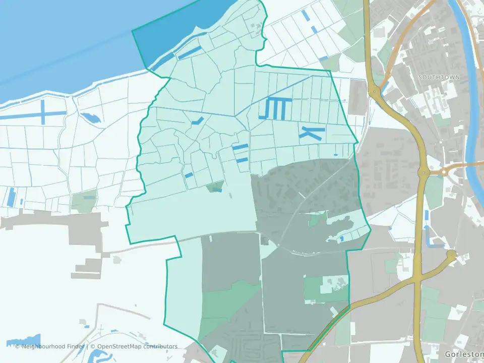
Gorleston
A quieter, pricier part of Gorleston, with recorded crime well below the Great Yarmouth rate
Gorleston at a glance
- House prices
- £280,000
- Middle46th percentile
- Schools
- 46th percentile
- Middle
- Transport
- 48th percentile
- Middle
- Crime rate
- 42.2 per 1,000 residents
- Strong80th percentile
- Flood risk
- 3% of the area in flood zones
- Middle35th percentile
Underlying data dates vary by measure.
How to read these figuresIs Gorleston a good place to live?
Gorleston-on-Sea is a seaside town across the River Yare from Great Yarmouth. This ward covers one part of it; Magdalen and Claydon wards cover much of the rest. Homes here cost more than across the borough: the median sale price was £280,000 in the 12 months to August 2026, against £215,000 across Great Yarmouth and £295,000 across England.
Recorded crime is low: police recorded 42 crimes and anti-social behaviour incidents per 1,000 residents over the same 12 months, against 110 across Great Yarmouth and 94 across England.
There is no railway station in Gorleston; Great Yarmouth station is about 3.5 miles from the centre of the ward. Magdalen, next door, is cheaper but records more crime; Bradwell South and Hopton costs less and also records relatively little.
This guide covers Gorleston ward, one part of Gorleston-on-Sea: 3 small census areas, 1.9 square kilometres and 5,285 residents at the 2021 Census. Magdalen and Claydon wards cover much of the rest of the town and have separate guides.
You can also compare nearby neighbourhoods in Great Yarmouth below.
How Gorleston compares
| Area | Crime and ASB per 1,000 | Violence and sexual offences per 1,000 | Median sale price |
|---|---|---|---|
| Gorleston | 42.2 | 18.5 | £280,000 (66) |
| Magdalen | 84.6 | 41.3 | £200,000 (50) |
| Bradwell South and Hopton | 65.4 | 29.3 | £240,500 (103) |
| Great Yarmouth | 109.9 | 51.0 | £215,000 (973) |
| England | 94.1 | 35.9 | £295,000 (502,418) |
In the same 12 months, detached homes in Gorleston ward sold for a median of £400,000 (31 sales) and terraced homes for £180,000 (22).
What to check before you move
- Look at the street, not just the ward. police.uk maps recorded crime month by month, so you can see whether incidents cluster in particular places or near the home you are considering.
- Try the journey at the times you would travel. There is no railway station in Gorleston; Great Yarmouth station is about 3.5 miles from the centre of the ward, and our data does not include bus frequencies.
- Check the flood map for the specific property. Small parts of the ward are in flood zones 2 or 3, and surface-water risk is mapped separately.
- Check school places directly. One primary school, Ormiston Cliff Park Primary Academy, and one secondary school, Cliff Park Ormiston Academy, are inside the ward; read the latest Ofsted reports and Norfolk County Council's admission rules, because living nearby does not guarantee a place.
Areas to compare with Gorleston
Magdalen
Great Yarmouth
Another Gorleston ward, to the north-west, with a lower median sale price, £200,000, and more recorded crime (85 per 1,000), though still below the England rate.
Read the Magdalen guideBradwell South and Hopton
Great Yarmouth
Neighbouring area to the west, covering southern Bradwell and Hopton-on-Sea, with low recorded crime (65 per 1,000) and a median sale price of £240,500.
Read the Bradwell South and Hopton guideSources: police.uk recorded crime (September 2025 to August 2026); ONS 2021 Census population; HM Land Registry Price Paid Data (September 2025 to August 2026); Environment Agency flood zones; NaPTAN station locations; Ofsted school register. Updated 4 November 2026.
Best fit and trade-offs
May suit
- People prioritising lower crime
Watch out for
Check the exact address, school admissions and your daily journeys. Area averages cannot describe every street.
No additional grounded watch-out bullets are available.
Crime rate in Gorleston
Crime rate
- Crime rate
- 42.2 per 1,000 residents
- Percentile
- 80th percentile nationally
Lower crime than most neighbourhoods nationally.
Recorded crimes and anti-social behaviour per 1,000 residents over the 12 months to August 2026. Higher crime percentiles indicate lower recorded crime. Busy centres can show high rates because crimes are counted where they happen but divided by the people who live there.
House prices in Gorleston
House prices
- Median sale price
- £280,000
- Percentile
- 46th percentile nationally
House prices are around the national middle range.
Median of 66 standard sales over the 12 months to August 2026, from HM Land Registry. Lower price percentiles indicate lower prices nationally. This is an area figure, not a valuation of a particular home.
Crime by type in Gorleston
Recorded crime by type
The largest recorded type in Gorleston is violence, sexual offences and weapons, at 18.5 per 1,000 residents: lower than Great Yarmouth (51.0) and lower than England (35.9).
| Type | Gorleston | Great Yarmouth | England |
|---|---|---|---|
| Violence, sexual offences and weapons | 18.5 | 51.0 | 35.9 |
| Anti-social behaviour | 6.4 | 12.7 | 10.7 |
| Theft, including shoplifting | 5.9 | 15.6 | 18.1 |
| Criminal damage and arson | 3.8 | 10.7 | 6.8 |
| Burglary | 2.5 | 3.2 | 3.7 |
| Public order | 2.3 | 8.0 | 6.6 |
| Vehicle crime | 1.1 | 2.6 | 5.3 |
| Drugs | 0.9 | 2.8 | 3.4 |
| Other crime | 0.8 | 2.5 | 2.2 |
| Robbery | 0.0 | 0.8 | 1.5 |
Recorded crime is not the same as personal risk. How to read crime figures for an area · Check another area
Schools in Gorleston
Schools
46th percentile nationally
Higher percentiles indicate stronger schools indicators nationally.
Flood risk in Gorleston
Flood risk
3% of the area in flood zones 2 or 3
Land in Environment Agency river and sea flood zones 2 or 3. Zone 3, the higher-probability zone, covers 2.8% of the area. That is the 35th percentile among neighbourhoods in England, where higher means more flood-zone land. Surface water is not included, and this is not an address-level assessment: check the flood map for the specific property.
Transport in Gorleston
Transport
48th percentile nationally
Higher percentiles indicate stronger transport indicators nationally.
FAQs
Is Gorleston a nice place to live?
It depends which part you mean. This ward records far less crime than Great Yarmouth as a whole and homes cost more, with a median sale price of £280,000 in the year to August 2026. Magdalen and Claydon, the other Gorleston wards, are cheaper. There is no railway station in Gorleston.
Is Gorleston safe?
Police recorded 42 crimes and anti-social behaviour incidents per 1,000 residents in this ward in the 12 months to August 2026, compared with 110 across Great Yarmouth and 94 across England. Recorded crime is not the same as personal risk, so check police.uk for the streets you are considering.
What are house prices like in Gorleston?
Homes in this ward sold for a median of £280,000 in the 12 months to August 2026, across 66 standard sales. Detached homes sold for a median of £400,000 and terraced homes for £180,000.
Is Gorleston a good place to live?
Gorleston may be a good fit for people who value lower crime. The available data also shows schools are around the national middle range. These headline measures are a starting point; check the specific home and the routes you would use.
How are schools in Gorleston?
Schools rank in the 46th percentile nationally for this public profile.
What neighbourhoods are near Gorleston?
Nearby public profiles include Bradwell North in Great Yarmouth and East Flegg in Great Yarmouth.