Normanton
Lower prices and its own station, with recorded crime above the England average
Normanton at a glance
- House prices
- £195,000
- Lower prices18th percentile
- Schools
- 40th percentile
- Middle
- Transport
- 86th percentile
- Strong
- Crime rate
- 102.7 per 1,000 residents
- Weak23rd percentile
- Flood risk
- 5.8% of the area in flood zones
- Middle54th percentile
Underlying data dates vary by measure.
How to read these figuresIs Normanton a good place to live?
Normanton is a small town in the City of Wakefield district, between Wakefield and Castleford. Its case for buyers is price and position: homes sold for a median of £195,000 in the year to June 2026, well below England's £295,000 and a little under the Wakefield district's £202,500, and the town has its own railway station, about 3 miles in a straight line from Wakefield Kirkgate and 8 miles from Leeds.
The trade-off is recorded crime. Police recorded 103 crimes and anti-social behaviour incidents per 1,000 residents over the same 12 months. That is lower than the Wakefield district rate of 118 but higher than England's 85, and violence and sexual offences make up almost half of it. Burglary is lower than both the district and England.
Normanton suits buyers who want more home for their budget close to Wakefield and Leeds, and who are prepared to check the specific streets they are considering. If lower recorded crime matters more to you than price, the neighbouring areas below cost more but record less.
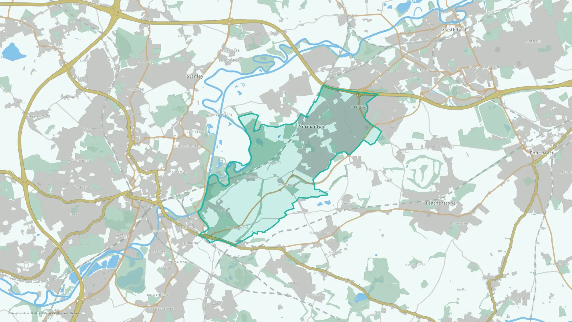
This guide covers Normanton ward: 10 small census areas, 15 square kilometres and 17,824 residents at the 2021 Census. Altofts, to the north-east, is in the separate Altofts and Whitwood ward, so its figures are not included here.
You can also compare nearby neighbourhoods in Wakefield below.
How Normanton compares
| Area | Crime and ASB per 1,000 | Violence and sexual offences per 1,000 | Median sale price | Land in flood zones |
|---|---|---|---|---|
| Normanton | 103.1 | 47.0 | £195,000 (147) | 5.8% |
| Crofton, Ryhill and Walton | 54.4 | 31.2 | £235,000 (141) | 2.5% |
| Stanley and Outwood East | 76.6 | 42.1 | £239,950 (233) | 8.0% |
| Wakefield district | 117.7 | 53.8 | £202,500 (3,312) | 8.7% |
| England | 84.5 | 33.8 | £295,000 (505,371) | 12.3% |
Price depends heavily on the type of home. In the same 12 months, terraced homes in Normanton sold for a median of £144,500 (50 sales), semi-detached homes for £198,000 (57) and detached homes for £315,250 (35).
What to check before you move
- Look at the street, not just the ward. police.uk maps recorded crime month by month, so you can see whether incidents cluster in particular places or near the home you are considering.
- Try the journey at the times you would travel. The station is in the town, but how useful it is depends on the timetable and where you need to get to.
- Check the flood map for the specific property. 5.8% of Normanton's land is in river or sea flood zones 2 or 3, and surface-water risk is mapped separately.
- Check school places directly. Five primary schools and one secondary school, Outwood Academy Freeston, are inside the ward; read their latest Ofsted reports and Wakefield Council's admission rules, because living nearby does not guarantee a place.
Areas to compare with Normanton
Crofton, Ryhill and Walton
Wakefield
About half Normanton's recorded crime rate (54 per 1,000) and a median sale price of £235,000. Transport access scores lower, so check journeys if you rely on public transport.
Read the Crofton, Ryhill and Walton guideStanley and Outwood East
Wakefield
Lower recorded crime (77 per 1,000) and a median sale price of £239,950, with stronger transport access than Crofton. Slightly more of its land is in flood zones (8.0%).
Read the Stanley and Outwood East guideSources: police.uk recorded crime (July 2025 to June 2026); ONS 2021 Census population; HM Land Registry Price Paid Data (July 2025 to June 2026); Environment Agency flood zones; NaPTAN station locations. Updated 6 October 2026.
Best fit and trade-offs
May suit
- Movers who value stronger transport access
- Buyers looking for lower house prices
Watch out for
- Crime data appears weaker than many neighbourhoods nationally
Crime rate in Normanton
Crime rate
- Crime rate
- 102.7 per 1,000 residents
- Percentile
- 23rd percentile nationally
Recorded crime is higher than in most neighbourhoods nationally.
Recorded crimes and anti-social behaviour per 1,000 residents over the 12 months to June 2026. Higher crime percentiles indicate lower recorded crime. Busy centres can show high rates because crimes are counted where they happen but divided by the people who live there.
House prices in Normanton
House prices
- Median sale price
- £195,000
- Percentile
- 18th percentile nationally
House prices appear lower than many neighbourhoods nationally.
Median of 147 standard sales over the 12 months to June 2026, from HM Land Registry. Lower price percentiles indicate lower prices nationally. This is an area figure, not a valuation of a particular home.
Schools in Normanton
Schools
40th percentile nationally
Higher percentiles indicate stronger schools indicators nationally.
Flood risk in Normanton
Flood risk
5.8% of the area in flood zones 2 or 3
Land in Environment Agency river and sea flood zones 2 or 3. Zone 3, the higher-probability zone, covers 3.8% of the area. That is the 54th percentile among neighbourhoods in England, where higher means more flood-zone land. Surface water is not included, and this is not an address-level assessment: check the flood map for the specific property.
Transport in Normanton
Transport
86th percentile nationally
Higher percentiles indicate stronger transport indicators nationally.
What the full report adds
This public guide covers headline signals for crime, house prices, schools, flood risk and transport. The full report adds deeper lifestyle, health, green space, family and local life data, plus tools to compare and shortlist neighbourhoods.
FAQs
Is Normanton a good place to live?
It depends on what you are prioritising. Normanton is cheaper than most of England, with a median sale price of £195,000 in the year to June 2026, and has its own railway station. Recorded crime is lower than the Wakefield district average but higher than England's, so it is worth checking the streets you are considering.
Is Normanton safe?
Police recorded 103 crimes and anti-social behaviour incidents per 1,000 residents in the 12 months to June 2026, compared with 118 across the Wakefield district and 85 across England. Recorded crime is not the same as personal risk, so check police.uk for the streets you are considering.
Where is Normanton?
Normanton is a town in the City of Wakefield district of West Yorkshire. Its railway station is about 3 miles in a straight line from Wakefield Kirkgate, 3 miles from Castleford and 8 miles from Leeds.
What are house prices like in Normanton?
Homes sold for a median of £195,000 in the 12 months to June 2026, across 147 standard sales. Terraced homes sold for a median of £144,500 and semi-detached homes for £198,000.
How are schools in Normanton?
Schools rank in the 40th percentile nationally for this public profile.
What neighbourhoods are near Normanton?
Nearby public profiles include Pontefract North in Wakefield and Wakefield North in Wakefield.